The Cohos Trail Association has a number of critical projects on the agenda in 2018, projects that will substantially improve the trail and the ability to stay out in the backcountry under a roof.
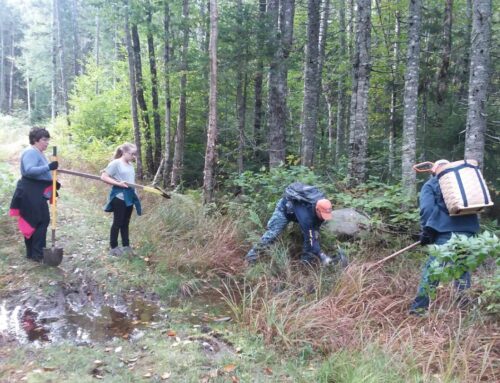
The all-volunteer trails group will also be utilizing contracted help to support the effort to clear extensive storm damage along scores of miles of pathway the length of Coos County, NH.
So, that said, here is a look at some of the things you can expect on the Cohos Trail during the hiking season in 2018.
Devil’s Rest Shelter
In late spring, the association will construct its fifth lean-to shelter and attendant composting latrine on the Cohos Trail. In the community of Stark, just a bit south of the junction of the Jimmy Cole Brook Road (grassy old logging lane) and the Old Summer Club Trail, the new Devil’s Rest Shelter will be erected within the Kauffmann Forest, a delightful 6,000-acre parcel of protected conservation land managed by the Society for the Protection of New Hampshire Forests.
The new shelter has already been milled out by the Garland Mill Timberframers of Lancaster, NH, the good folks who run the historic water-powered sawmill at the eastern margins of town. It will be somewhat similar in size and design to the existing shelter they helped create for us that resides on Sugarloaf Arm in Stratford Township. The shelter will be able to sleep up to eight individuals. It will be accompanied by a fine composting latrine fabricated by Jack Pepau, who lives in the nearby community of Stark. Jack and his son Chad (former president of the association) have fabricated many a composting latrine for the association and other trail groups.
The location of the shelter will be about one-quarter mile south of the main route of the Cohos Trail (Jimmy Cole Brook Road and Old Summer Club Trail junction). The way to the shelter will be well marked so there will be no problem finding the facility. Once there, please be aware that campfires are strictly forbidden at the site. If you stay at the facility please use Leave No Trace practices and pack everything out with you, and we do mean everything.
It will be possible after a long haul over the course of a full day to reach the Devil’s Rest Shelter from the Mount Cabot Cabin deep in the Kilkenny wilderness. There are no roofed shelters between Cabot and the site of the Devil’s Rest, but there are two formal campsites, one at Unknown Pond and one below Roger’s Ledge and near the junction of the Kilkenny Ridge Trail and the Mill Brook Trail. But for those who are hell-bent on sleeping beneath a roof, it will be possible to do so provided one puts in the effort to cover some seventeen miles between the Mt. Cabot watchman’s cabin and the new shelter.
Moose Alley Trail Rebuild
On Saturday, June 2, National Trails Day, volunteers will assemble near the Magalloway Road bridge over the Connecticut River and northward near Big Brook Bridge on Route 3 where the trailheads of the Moose Alley Trail are located. Once on site, two separate volunteer crews – one starting at the Magalloway Road trailhead near the Connecticut River and one a mile and a half north – will work to restore the Moose Alley Trail which was subject to logging over most of its length in 2017. The northern crew will clean up a small stretch at the northern end to the junction of the Falls in the River Trail, then rejoin the southern crew for the majority of the effort.
Volunteers will have their work cut out for them removing extensive amounts of debris, cutting obstacles out of the trail, rerouting the pathway in places, adding blaze stakes and blaze paint throughout, filling skidder ruts, and the like in order to make the trail route passable and fully visible to the hiking public.
The Moose Alley Trail is a critical link in the Cohos Trail system and restoring it is a high priority, indeed. Hikers moving along the trail will find most of the forest has been removed by logging and logging litter will be evident on all sides. There is one bit of silver lining, however. The timber cut opened up views in the region which were not available to the hiking public before.
The association welcomes anyone who would like to participate in the effort to restore the Moose Alley Trail. To keep appraised of the project, go to Friends of the Cohos Trail on Facebook periodically and check in for upcoming information, or check our website.
The Cohos Trail is, after all, located in places within working forests, forests that are cut to supply local sawmills, regional paper mills, and regional biomass energy plants with raw material to create products and generate power. The forest economy in the county makes it possible for huge tracts of forested land to remain undeveloped. These vast tracts of timber benefit more than industry. The trees provide a great regional carbon sink, habitat for countless animals and plants, filters for surface water to keep it clean, a wonderful recreational environment for many different users, and income for local citizens up and down the length of New Hampshire’s largest county.
Sugar Hill Trail Rebuild
The Sugar Hill Trail south of Coleman State Park was also impacted (although less so) by logging in 2017. The association has contracted with the NorthWoods Stewardship Center for a crack pro crew to spend a day or two out on the Sugar Hill Trail cleaning up debris, reestablishing the route, leveling treadway impacted by machinery, adding blaze stakes and blaze paint, and generally making the trail suitable for hiking traffic. It is likely that the restoration effort on this pathway will take place either late in the first week or early in the second week of June.
If you are planning on hiking the trail early in the season, you should expect to encounter this logging cut and the one that impacted the Moose Alley Trail. Be aware that the trails will not be reestablished if you hike early, so you will either have to backtrack, use roads of old skidways to get around the problem areas, or you will have to pick your way at your own risk through the cuts in much less than ideal conditions and without the aid of blazed trees.
Contracted Trail Sweep
Extensive storm damage in the forests of Coos County, NH has prompted the Cohos Trail Association to contract for two weeks with a crew from the NorthWoods Stewardship Center of E. Charleston, Vermont, to thoroughly sweep the trail of blowdowns and debris, particularly in the vast mountainous region between Route 110 in Stark and Coleman State Park in Stewartstown, as well as lands where some trails reside in 300,000-acre Pittsburg Township. The Gadwah Notch area, more than most stretches of the CT, needs considerable work to make the route suitable for passage.
In order to make the long trail route safe for hikers this year, the association felt it needed the help of a pro crew to clear the treadway over many miles. So when hiking season begins in earnest in July, the pathways that make up the Cohos Trail system should be well cleared of problems from Stark much of the way to the Canadian border.
This effort has been made possible by an anonymous donor who has gifted the association with many thousands of dollars for the purpose of improving the trail and its infrastructure.
Reblazing a Priority
The Cohos Trail is blazed in yellow paint throughout its entire distance north of Route 115, from Jefferson to the Canadian border. South of Route 115 the various White Mountain National Forest trails in the system have various colored paint blazes as anyone who has hiked the entire trail knows.
Where we can influence the blaze colors, the Cohos Trail is blazed in that single yellow color. This year, we will make a concerted effort to touch up and add blazing throughout the entire trail system so that following the trail is easier than ever and less confusing in a few spots. We will also add additional signage and direction arrows to help hikers navigate the system, particularly in the area between Danforth Road and Round Pond Brook Road and the Round Pond Brook Trail in Pittsburg Township.
We are asking all trail adopters to apply or touch up 2×8-inch blazes with yellow latex paint applied with 2-inch foam brushes along the route of their respective trails. Other volunteers will march out into the backcountry with paint, too, to touch up blazing on trails that have not been adopted.
Please be aware that there are exceptions to the yellow color on spur trails that are a part of the Cohos Trail system. For instance, the Percy Peaks Trail is blazed in orange; the Deer Mountain Firetower Trail is blazed in blue. The Sanguinary Ridge Trail (part of the main Cohos Trail) also exhibits white blazes along with the yellow and has for decades. In some areas, old red logging blazes show up as do royal blue State of NH blazes. But the main path of the Cohos Trail is always blazed in yellow. If you have a yellow blaze in your face, you are on the right track.
Some Trail Closures in the Whites
Please be aware that there are some trails closed in the White Mountains due to very recent storm and flood damage. Those closures do not affect the route of the Cohos Trail to any great degree. However, the Cohos Trail does use a very short segment of the Dry River Trail deep in the Dry River Valley. The main trail is closed. But the less than quarter mile segment that the CT runs on should not be problematical.
Former Southbound Databook Alert
If you have any Southbound Databook that is not the 2018 version, there is one glaring mistake that you must be aware of. In the beginning of the Nash Stream Forest chapter, it states that when leaving the Baldhead Shelter on Baldhead Mountain one should turn right to head south. That is incorrect. One should turn left (southwest) and head south.
The Neil Tillotson Hut is Open
The new Neil Tillotson Hut shelter in the Connecticut Lakes State Forest was completed last year and is open to the public. There is now a place to camp legally halfway between Lake Francis State Campground and Deer Mountain State Campground. There is a new ADA (American Disabilities Act) compliant composting latrine 100 feet from the shelter, and there is water in a gulley very close by just to the north.
Layout of a New Trail
In 2018, the Cohos Trail Association hopes to have a route laid out for a direct pathway due north out of Coleman State Park to link the park to the inlet bridges at 1,000-acre Lake Francis seven miles away. It is our hope that in 2019 we will be able to brush out a straight-shot pathway north so that we may eliminate lots of road walking and ATV-traveled corridors that the Cohos Trail runs on in the Deadwater region of Stewartstown and Clarksville Townships.
Once landowner and state approvals are in hand, the layout work will be carried out by volunteers and by skilled individuals with the NorthWoods Stewardship Center. Their work will be underwritten by a $2,200 grant from the Neil and Louise Tillotson Fund, administered by the New Hampshire Charitable Foundation. Those funds will be used to explore terrain, GPS a suitable route, and flag it.
Cohos Trail Tourist Place Card
An effort is underway to create a full-color, two-sided place card for tourist information kiosks all over the North Country and in State outlets in the hopes of increasing Cohos Trail exposure.
The association has applied for a Coos Economic Development Corporation grant to underwrite the effort. If we are fortunate enough to procure a small grant, we will proceed with the design and printing of the place card and with providing guidebooks for local campgrounds and hotels.
Lose the Traffic Jam Blues
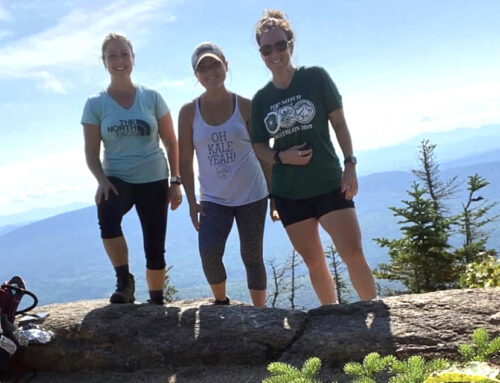
Appalled by two-mile-long lines of parked cars on the margins of North Country highways, piloted there by hikers who want to tramp the high peaks of the Franconia and Presidential Ranges? Who isn’t! The Cohos Trail is not too much farther north, you know. Hiking is wonderful in the Pondicherry Wildlife Refuge, in the Kilkenny wilderness, in the rugged Nash Stream Forest, craggy Dixville Notch, and in the vast Connecticut Lakes Region all the way up to the boundary peaks on the Canadian border. The mighty Cohos Trail is calling you north. Answer the call.